Showing posts with label environment. Show all posts

Tuesday, July 14, 2020

The Importance of "Dirty" Rivers

Complex river systems are the foundation of much of what we have to enjoy here on this planet. They support wildlife populations, provide soil nutrients, and so much more. Humans have had a profound impact on river systems, however, changes in current practices and increased focus on restoring rivers to their natural status can make a major difference in our lives. 

Image Source: pixabay.com


Think of your local river. The place you take a walk when you’re looking for solitude or comfort in nature. The place you take your children fishing. Or perhaps where you go when you’re looking for relief from the brutal summer heat.

Chances are, that the river that you love for all the nature it brings into your life really isn’t all that natural. In fact, the majority of the river systems in our world today have been significantly altered by humans whether we recognize the changes we have made throughout history or not. A vast number of our river systems have been greatly simplified — they aren’t as messy or complex as they really should be.

Though in many ways these changes have produced some benefit for people at some point in time, they are catching up with us. Simplified rivers are not as resilient and the ecological damage we have inadvertently caused could come back to haunt us within our lifetimes. Small changes in our habits and priorities could lead to greater changes that will benefit our river ecology and could just save us all.

Complex Rivers

When we think of a complex, natural, healthy river, we are really talking about one of the greatest natural feats of engineering available in the world. These rivers have ebbs and flows that the foundations of the surrounding ecosystems are built around. They have variability in pitch and depth that creates homes for numerous species that our society depends upon. 

These complex rivers collect and move sediment across a landscape. For instance, seasonal flooding refreshes the floodplains with minerals and nutrients brought down by the river from mountain erosion and decomposing substances. This influx of sediment is critical for the long-term growth and survival of native vegetation and forms the basis of the food chain that all animals are part of.

Finally, a complex river is one that is resilient. It — and the surrounding habitats it supports — are able to recover from unexpected natural events and thrive after a short period. Many experts believe that healthy rivers and surrounding ecosystems are absolutely critical to our ability to deal with climate change. Basically, the more healthy, intact natural areas we have, the better our chances are in the long-run.

Human Impacts

Once humans entered the equation things began to change. Typically that which benefited us in the short-term negatively impacted the entire ecosystem (including future generations of humans) in the long-term. For instance, dams and overfishing have powered many of our cities and made many people rich selling food, but they have altered the geomorphology of streams, ruined quality habitat, and caused populations we could be sustainably harvesting today to crash.

Many dams built back in the day are reaching a point where they are requiring more and more maintenance to keep up. Many of them are a collecting point for sediment, which hinders the sediment renewal cycle in floodplains downstream and leads to decreases in soil and vegetation health. Furthermore, the sediment causes wear and tear on the dams and must be monitored regularly.

It may come as a shock with all of the environmental regulations that have been put in place since the 1960s, but one study conducted in 2013 found that nearly half of America’s rivers were still too polluted to be healthy for people, let alone the ecosystems they originally supported. The current administration has worked diligently to roll back numerous environmental regulations, so it can only be assumed that these rivers and possibly more will remain too polluted.

Polluted and unhealthy rivers also pose a more direct impact on our health. For example, different forms of human-caused pollution in rivers can lead to the growth of different bacterias that can make people seriously ill. It is one of many ways that diseases of the future could evolve to pandemic level proportions.

Contributed by Indiana Lee: Indiana Lee is a  journalist from the Pacific Northwest with a passion for covering workplace issues, environmental protection, social justice, and more. When she is not writing you can find her deep in the mountains with her two dogs. Follow her work on Contently, or reach her at indianaleewrites@gmail.com

Tuesday, February 25, 2020

Where does energy in U.S come from? [Guest Article]

From burning firewood to using electricity from renewable sources, the home energy landscape has drastically changed over the last 150 years. This article and infographic explore the history of energy use and what the sustainable future may look like.

We no longer have to gather firewood for our wood-burning stoves to keep us warm at night, but there are a variety of energy sources used in each home. Most homes in the U.S. run on either electricity or natural gas, or a combination of both, but homeowners may also employ solar panels or even residential wind-powered solutions too. 


Looking at the charts below, you can see that energy consumption has grown significantly each year and in 2018, it hit an all-time high. However, you’ll notice some changes in the way we use each energy source. Coal is the only energy source below that has suffered a decline and renewable energy has recently surpassed nuclear energy. As new technologies are developed, we are finding new ways to meet the increased energy demand. The future of energy consumption will look very different than it does today.

home energy use infographic


Where does energy in US come from?
By no surprise, oil has been the largest and most popular source of energy. Since the 1950s, oil and natural gas were used to heat homes. Now in 2020, you know that petroleum is used for many other reasons and industries, from powering our cars to packaging products in plastic. 

Although coal was another popular source of energy, it has been on the decline for the last few decades. It’s less efficient than other sources and negatively impacts the environment. To answer that problem, the U.S. has been investing in renewable energy sources. Wind, solar, and geothermal energy are proving to be great resources for a clean future.

Are renewables the future?
Although only 11% of U.S. energy production comes from renewable sources, it is expected to grow. Solar, wind, and geothermal technology energy are three of the top sources for renewable energy. Among those, wind is the fastest growing and judging from the production map, it has wide geographic potential as well. Geothermal energy, which uses underground temperatures to transfer energy, is becoming a popular alternative for home heating and cooling. Of course, residential solar panels are gaining wide adoption as well. As renewable energy options become more available, the energy consumption landscape is likely to move toward a more sustainable future. 

This infographic from The Zebra walks through the history of energy use, where energy is produced, and what the future of energy may look like.
Author bio: Amanda Tallent is a writer who covers everything from business to lifestyle. She creates content to help people live more informed and confident lives. 
Want to write guest blog for us? See guidelines here

Monday, April 15, 2019

Factors Controlling the Shape of a River Delta

What is a Delta?
A delta is an accumulation of sediments at the mouth of a river that may consist of a network of distributary channels, wetlands, bars, tidal flats, natural levees and beaches that typically shift from on location to another. Delta shape is dependent of dominant current conditions where the mouth of the river: tide-, sea wave-, and storm-dominated.

Lena River Delta, Siberia.
Factors that control the shape of a River Delta? 


River deltas around the world are very different. The shape of a river delta is controlled by a variety of factors including:
• the volume of river discharge.
• the volume of sediment being deposited in a delta region.
• vegetation cover in delta regions capable of trapping sediments.
• tidal range conditions where the river enters the ocean.
• storm-related climate and oceanographic conditions.
• coastal geography (mountains or plains) in coastal regions.
• human activity is now a dominant factor influencing the shape of river deltas.

Yellow River Delta, China
Nile River Delta, Egypt.
River deltas like the Amazon and Indus Rivers discharge into the ocean where a high tidal range influence flow into and out of the mouth of the rivers. Some river delta region are highly effected by erosion effects of storms and high wave energy. Infrequent but intense superstorms impact the shape of deltas and shoreline, such as the impact of hurricanes on the Gulf Coast.

Indus River Delta, Pakistan

Human activity is responsible for the irregular shape of the Birdfoot Delta on the Mississippi River created by the constant dredging to keep shipping channels clear. The construction of dams and diversion of water out of the Colorado River has essentially shut of the supply of water and sediment to the Colorado River Delta in the Gulf of California.

The Mississippi Birdfoot Delta is largely controlled by Human activities
Changes to Mississippi River Delta over the last 4000 years ago.
A river no more. Very little water makes it to the Colorado River Delta


Thanks to Dr. Phil Stoffer for assisting in publishing this article.

Friday, February 17, 2017

Earthquake Precursors: Signs Before Earthquakes


Earthquake prediction is the ultimate goal of seismologists. Being able to predict when and where an earthquake will occur could save thousands, if not hundreds of thousands, of lives, over the years. Even after decades of study, earthquake forecasting remains notoriously difficult, however. So what are the signs which occur b
efore 
an earthquake – earthquake precursors – and how useful are they?


About the author (who writes this article): Nusrat Kamal Siddiqui is one of the leading Geoscientists from Pakistan. He has a diverse professional career of being a Petroleum Geologist, Hydrologist and Engineering Geologist, both in Pakistan and overseas. He recently published a book " Petroleum Geology, Basin Architecture and Stratigraphy of Pakistan". Click here for further details about the book.


The Precursors

There are some long-term, medium-term and short-term precursors of seismic activity that cause earthquakes.

The long-term precursors are based on statistical studies and the prediction is probabilistic. The medium-term precursors help in predicting the location of an earthquake to a sufficient degree of accuracy. The short-term precursors of seismic events are indicated by changes in geomagnetic field, changes in gravity field, rising of subsurface temperature and rise in ground radioactivity. Agriculture institutions record subsurface temperature at 20, 50 and 100 cm depth as it is useful for monitoring crop growth. In earthquake-prone areas the temperature starts rising about 700-900 days before the event. This readily available data can be of help.

The short-term precursors are more important as they can be observed by a common man, and happen from a few days before the earthquake to just before it happens. With a reducing lag time these are: rise in water in the wells with increased sediments, sudden increase and decrease in river water flow, disturbance in the reception of radio, television, telephones, water fountains on the high grounds, strange behavior of animals, a sudden jump in the number of deliveries in hospitals and malfunctioning of cell phones. These days cell phones are the most handy and common piece of electronic equipment. A general collapse of this system can be noted by masses, and hence could be a very effective means to take timely mitigation measure. It has been found that about 100 to 150 minutes before the earthquake the cell phones start malfunctioning. However, the humans are very careless by nature and there would be only very few who would be observant enough to note the above precursors.  


It is indeed believed that animals exhibit unusual behavior before an earthquake


In the earthquake-prone areas groups of observant and responsible people (including women - they normally haul the water) may be constituted wherein the list of precursors, in local languages, may be distributed and some training imparted. And this exercise may not 
be left to the authorities, for obvious reasons!

Source: Earthquakes are inevitable, Disasters are not– Mitigation, therefore, is better than Prediction by Nusrat K. Siddiqui


Suggested Readings:

1. A systematic compilation of earthquake precursors
2. Earthquakes: prediction, forecasting and mitigation
3. Earthquake Prediction, Control and Mitigation

Sunday, January 8, 2017

Different shale distributions in low resistivity log response.


                   First, we will start with a small introduction about the resistivity logs                                           

Resistivity log

Technique : produce a current in the adjacent formation and measure the response of the formation to that current.

Resistivity logs are used to:

• determine hydrocarbon-bearing versus water bearing zones
• indicate permeable zones
• determine porosity

By far the most important use of resistivity logs is the determination of hydrocarbon-bearing versus water-bearing zones. Because the rock’s matrix or grains are non-conductive and any hydrocarbons in the pores are also non-conductive, the ability of the rock to transmit a current is almost entirely a function of water in the pores. As the hydrocarbon saturation of the pores increases (as the water saturation decreases), the formation’s resistivity increases. As the salinity of the water in the pores decreases , the rock’s resistivity also increases.

Resistivity tools principle : there are two types of resistivity tool , The dual lateral log ( DLL ) and the induction log ( DIL ) both types measures the resistivity in three zones simultaneously.

LLD looks deep into reservoir

LLS Looks shallow into the reservoir


MSFL reads the resistivity close to the wellbore.


Low Resistivity response :

High deep resistivity means : HCs or Tight streak  { low porosity }

Low deep resistivity means : Shale or wet sand.


Shale: Shale is defined as a fine-grained, indurated detrital sedimentary rock formed by the consolidation (by compression or cementation) of clay, silt, or mud.
It is characterized by a finely stratified structure of laminae ranging from 0.1 to 0.4 mm thick. Shale contains an appreciable content of clay minerals or derivatives from clay minerals, with a high content of detrital quartz; containing at least 50% silt, with 35% clay or mica fraction, and 15% chemical or authigenic materials
In petrophysical analysis, shale volume is one of the key answers used later to correct porosity and water saturation for the effects of clay bound water, (CBW).


Shale distribution in shaly sand :
 
Shale can be distributed in several different ways, as shown below.

Laminated shale is a special case in petrophysical analysis. Standard models for porosity and saturation do not work.
Dispersed shale is usually composed of from clay minerals that form in place after deposition due to chemical reactions between the rock minerals and the chemicals in the formation water.
Structural shale is usually deposited as particles, grains, or clasts during the initial depositional phase. For example, the flooding of a river valley can carry mud or shale from surrounding areas.
Different shale distributions have different effect on the sand reservoir.
In a sand reservoir contain structure shale : it will affect the reservoir porosity
In a sand reservoir contain laminae shale : it will affect only the net pay of the reservoir

In a sand reservoir contain : it will affect the porosity and permeability of the reservoir and also it will lead to a shortcut in the resistivity log response , which may result in a miss lead in the interpretation of the reservoir porosity and saturation  , it could be interpreted as sand bearing water instead of a sand contain dispersed shale.
So, the question here is how to differentiate between them and to avoid this wrong interpretation ?!
Let’s assume that you have a 100% clean sand reservoir. So the total porosity of this reservoir is 30% and the sand grains will represent 70% of the volume of the reservoir
Hint : Porosity of sandstone is 30 % and porosity of shale is 10%

Case 1 :

In the case of the presence of structure shale ,
So in this case shale grains will replace sand grains ( volume of 70% ) , the shale will bring its 10% porosity with it.
In other words , The porosity will be enhanced by 10% in the volume of 70% of the sand
So , the porosity will increase by 70/10 and the total porosity will be = 37 %


Case 2 :
In the case of the presence of laminae shale , in this case shale will replace the whole reservoir ( 100 & ) and also will bring its own 10% porosity.
In other words , the porosity will be reduced from 30% to 10%
Case 3 :
In the case of the presence of dispersed shale , in this case shale we will replace the porosity  volume it self ( 30 % ) and as usual it will bring its own porosity.
 
In other words , the porosity will be reduced into 3% ( 30 / 10 )Summarized figure for the different shale distributions in shaly sand reservoir and it’s effect on the reservoir porosity.
Shale distribution model proposed by Thomas and Stieber (Tyagi et al. 2009). Here Vshale is the volume of shale, φtotal is the total porosity, φmax is the maximum porosity, and φsh is the porosity in shale

Conclusion :


 So, we can differentiate between the three different types of shale distribution and according to the type we can make the right interpretation for the porosity and the saturation of the sand reservoir , also we will avoid the miss leading interpretation in the shortcut in the resistivity log.


Photo Credits: Ahmed Adel
Originally blog is written by Ahmed Adel 


Thursday, January 7, 2016

Desert Landscapes and Life

Desert Landscapes and Life 

The popular media commonly portray deserts as endless vistas of sand, punctuated by the occasional palm-studded oasis. In reality, not all desert landscapes are buried by sand. Some deserts  are vast, rocky plains; others sport a stubble of cacti and other hardy desert plants; and still others display intricate rock formations that look like medieval castles. Explorers of the Sahara, for example, traditionally distinguished among hamada (barren, rocky highlands), reg (vast, stony plains), and erg (sand seas in which large dunes form). 
In this post, we’ll see how the erosional and  depositional processes described above lead to the formation of such contrasting landscapes.

Deposition in Deserts

Deposition in Deserts

We've seen that erosion relentlessly eats away at bedrock and sediment in deserts. Where does the debris go? Below, we examine the various desert settings in which sediment accumulates.

Talus Aprons 

Production and transportation of debris and sediment in deserts.
Over time, joint-bounded blocks of rock break off ledges and cliffs on the sides of hills. Under the influence of gravity, the resulting debris tumbles downslope and accumulates as talus, a pile of debris at the base of a hill. Talus can survive for a long time in desert climates, so we typically see aprons of talus  fringing the bases of cliffs in deserts (figure above a).

Friday, December 18, 2015

Coastal Landforms

Where Land Meets Sea: Coastal Landforms

Tourists along the Amalfi coast of Italy thrill to the sound of waves crashing on rocky shores. But in the Virgin Islands sunbathers can find seemingly endless white sand beaches, and along the Mississippi delta, vast swamps border the sea. Large, dome-like mountains rise directly from the sea in Rio de Janeiro, Brazil, but a 100-m-high vertical cliff marks the boundary between the Nullarbor Plain of southern Australia and the Great Southern Ocean. As these examples illustrate, coasts, the belts of land bordering the sea, vary dramatically in terms of topography and associated landforms. 

Beaches and Tidal Flats 

Characteristics of beach, barrier islands and tidal flats.
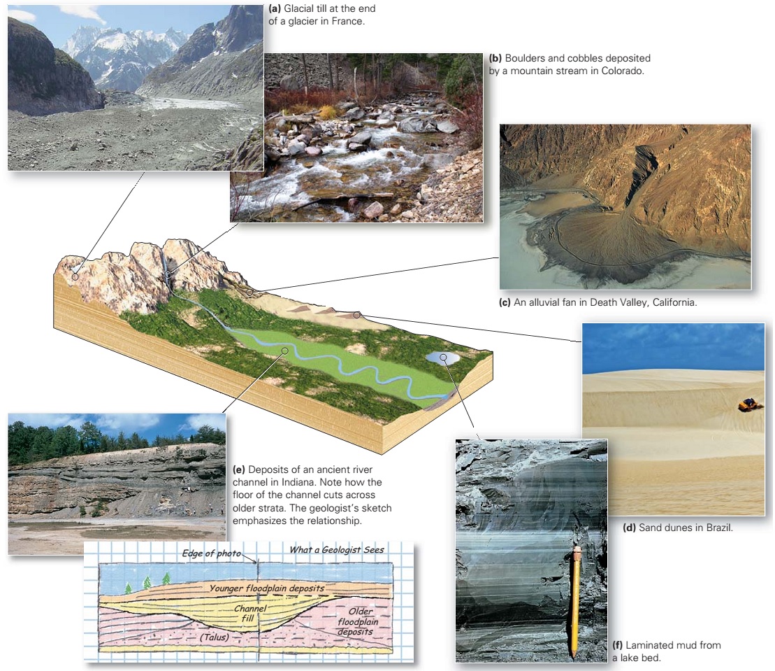
For millions of vacationers, the ideal holiday includes a trip to a beach, a gently sloping fringe of sediment along the shore. Some beaches consist of pebbles or boulders, whereas others consist of sand grains (figure above a, b). This is no accident, for waves winnow out finer sediment like silt and clay and carry it to quieter water, where it settles. Storm waves, which can smash cobbles against one another with enough force to shatter them, have little effect on sand, for sand grains can’t collide with enough energy to crack. Thus, cobble beaches exist only where nearby cliffs supply large rock fragments. 
The composition of sand varies from beach to beach because different sands come from different sources. Sands derived from the weathering and erosion of silicic-to- intermediate rocks consist mainly of quartz; other minerals in  these rocks chemically weather to form clay, which washes away  in waves. Beaches made from the erosion of limestone, or of  coral reefs and shells, consist of carbonate sand, including masses of sand-sized chips of shells. And beaches derived from  the erosion of basalt boast black sand, made of tiny basalt grains.
A beach profile, a cross section drawn perpendicular to the shore, illustrates the shape of a beach (figure above c). Starting from the sea and moving landward, a beach consists of a foreshore zone, or intertidal zone, across which the tide rises and falls. The beach face, a steeper, concave-up part of the foreshore zone, forms where the swash of the waves actively scours the sand. The backshore zone extends from a small step, cut by high-tide swash to the front of the dunes or cliffs that lie farther inshore. The backshore zone includes one or more berms, horizontal to landward-sloping terraces that receive sediment only during a storm. 
Geologists commonly refer to beaches as “rivers of sand,” to emphasize that beach sand moves along the coast over time it is not a permanent substrate. Wave action at the shore moves an active sand layer on the sea floor on a daily basis. Inactive sand, buried below this layer, moves only during severe storms or not at all. Longshore drift, discussed earlier, can transport sand hundreds of kilometres along a coast in a matter of centuries. Where the coastline indents landward, beach drift stretches beaches out into open water to create a sand spit. Some sand spits grow across the opening of a bay, to form a baymouth bar (figure above d). 
The scouring action of waves sometimes piles sand up in a narrow ridge away from the shore called an offshore bar, which parallels the shoreline. In regions with an abundant sand supply, offshore bars rise above the mean high-water level and become barrier islands (figure above e), and the water between a barrier island and the mainland becomes a quiet-water lagoon, a body of shallow seawater separated from the open ocean. Though developers have covered some barrier islands with expensive resorts, in the time frame of centuries to millennia, barrier islands are temporary features and may wash away in a storm.
Tidal flats, regions of clay and silt exposed or nearly exposed at low tide but totally submerged at high tide, develop in regions protected from strong wave action (figure above f). They are typically found along the margins of lagoons or on shores protected by barrier islands. Here, sediments accumulate to form thick, sticky layers. 

Rocky Coasts 

Erosion landforms of rocky shorelines.
More than one ship has met its end, smashed and splintered in the spray and thunderous surf of a rocky coast, where bedrock cliffs rise directly from the sea. Lacking the protection of a beach, rocky coasts feel the full impact of ocean breakers. The water pressure generated during the impact of a breaker can pick up boulders and smash them together until they shatter, and it can squeeze air into cracks, creating enough force to push rocks apart. Further, because of its turbulence, the water hitting a cliff face carries suspended sand and thus can abrade the cliff. The combined effects of shattering, wedging, and abrading, together called wave erosion, gradually undercut a cliff face and make a wave-cut notch (figure above a). Undercutting continues until the overhang becomes unstable and breaks away at a joint, creating a pile of rubble at the base of the cliff that waves immediately attack and break up. In this process, wave erosion cuts away at a rocky coast, so that the cliff gradually migrates inland. Such cliff retreat may leave behind a wave-cut bench, or platform, that becomes visible at low tide (figure above b). 
Other processes besides wave erosion break up the rocks along coasts. For example, salt spray coats the cliff face above the waves and infiltrates into pores. When the water evaporates, salt crystals grow and push apart the grains, thereby weakening the rock. Biological processes also contribute to erosion, for plants and animals in the intertidal zone bore into the rocks and gradually break them up. 
Many rocky coasts are irregular with headlands protruding into the sea and embayments set back from the sea. Wave energy focuses on headlands and disperses in embayments, a result of wave refraction. The resulting erosion removes debris at headlands, and sediment accumulates in embayments (figure above c). In some cases, a headland erodes in stages (figure above d). Because of refraction, waves curve and attack the sides of a headland, slowly eating through it to create a sea arch connected to the mainland by a narrow bridge. Eventually the arch collapses, leaving isolated sea stacks just offshore (figure above d). Once formed, a sea stack protects the adjacent shore from waves. Therefore, sand may collect in the lee of the stack, slowly building a tombolo, a narrow ridge of sand that links the sea stack to the mainland.

Estuaries 

The Chesapeake Bay estuary formed when the sea flooded river valleys. The region is sinking relative to other coast areas because it overlies a buried meteor crater.
Along some coastlines, a relative rise in sea level causes the sea to flood river valleys that merge with the coast, resulting in estuaries, where seawater and river water mix. You can recognize an estuary on a map by the dendritic pattern of its river-carved coastline (figure above). Oceanic and fluvial waters interact in two ways within an estuary. In quiet estuaries, protected from wave action or river turbulence, the water becomes stratified, with denser oceanic salt water flowing upstream as a wedge beneath less-dense fluvial freshwater.  In turbulent estuaries, oceanic and fluvial water combine to create nutrient-rich brackish water with a salinity between that of oceans and rivers. Estuaries are complex ecosystems inhabited by unique species of shrimp, clams, oysters, worms, and fish that can tolerate large changes in salinity.

Fjords 

Fjord landscapes form where relative sea-level rise drowns glacially carved valleys.
During the last ice age, glaciers carved deep valleys in coastal mountain ranges. When the ice age came to a close, the glaciers melted away, leaving deep, U-shaped valleys. The water stored in the glaciers, along with the water within the vast ice sheets that covered continents during the ice age, flowed back into the sea and caused sea level to rise. The rising sea filled the deep valleys, creating fjords, or flooded glacial valleys. Coastal fjords are fingers of the sea surrounded by mountains; because of their deep-blue water and steep walls of polished rock, they are distinctively beautiful (figure above).

Coastal Wetlands 

Examples of coastal wetlands.
A flat-lying coastal area that floods during high tide and drains during low tide, but does not get pummeled by intense waves, can host salt-resistant plants and evolve into a coastal wetland. Wetland-dominated shorelines are sometimes called “organic coasts.” Researchers distinguish among different types of coastal wetlands based on the plants they host. Examples include swamps (dominated by trees), marshes (dominated by grasses; figure above a), and bogs (dominated by moss and shrubs). So many marine species spawn in wetlands that as a whole, wetlands account for 10% to 30% of marine organic productivity. 
In tropical or semitropical climates (between 30 north and 30 south of the equator), mangrove trees may become the dominant plant in swamps (figure above b). Some mangrove species form a broad network of roots above the water surface, making the plant look like an octopus standing on its tentacles, and some send up small protrusions from roots that rise above the water and allow the plant to breathe. Dense mangrove swamps counter the effects of stormy weather and thus prevent coastal erosion.

Coral Reefs 

The character and evolution of coral reefs.
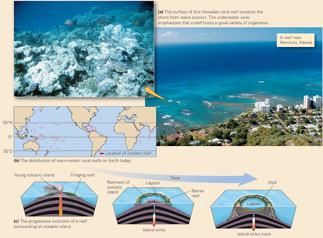
Along the azure coasts of Hawaii, visitors swim through colorful growths of living coral. Some corals look like brains, others like elk antlers, still others like delicate fans (figure above a). Sea anemones, sponges, and clams grow on and around the coral. Though at first glance coral looks like a plant, it is actually a colony of tiny invertebrates related to jellyfish. An individual coral animal, or polyp, has a tubelike body with a head of tentacles. 
Coral polyps secrete calcite shells, which gradually build into a mound of solid limestone whose top surface lies from just below the low-tide level down to a depth of about 60 m. At any given time, only the surface of the mound lives the mound’s interior consists of shells from previous generations of coral. The realm of shallow water underlain by coral mounds, associated organisms, and debris comprises a coral reef. Reefs absorb wave energy and thus serve as a living buffer zone that protects coasts from erosion. Corals need clear, well-lit, warm (18–30C) water with normal oceanic salinity, so coral reefs grow only along clean coasts at latitudes of less than about 30 (figure above b). 
Marine geologists distinguish three different kinds of coral reef, on the basis of their geometry (figure above c). A fringing reef forms directly along the coast, a barrier reef develops offshore, and an atoll makes a circular ring surrounding a lagoon. As Charles Darwin first recognized back in 1859, coral reefs associated with islands in the Pacific start out as fringing reefs and then later become barrier reefs and finally atolls. This progression reflects the continued growth of the reef as the island around which it formed gradually sinks. Eventually, the reef itself sinks too far below sea level to remain alive and becomes the cap of a flat-topped seamount known as a guyot.

Tuesday, November 10, 2015

Recognizing Depositional Environments

How Do We Recognize Depositional Environments? 

Geologists refer to the conditions in which sediment was deposited as the depositional environment. Examples include beach, glacial, and river environments. To identify depositional environments, geologists, like crime scene investigators, look for clues. Detectives may seek fingerprints and bloodstains to identify a culprit. Geologists examine grain size, composition, sorting, bed-surface marks, cross bedding, and fossils to identify a depositional environment. Geological clues can tell us if the sediment was deposited by ice, strong currents, waves, or quiet water, and in some cases can provide insight into the climate at the time of deposition. With experience, geologists can examine a succession of beds and determine if it accumulated on a river floodplain, along a beach, in shallow water just offshore, or on the deep ocean floor.
Let’s now explore some examples of different depositional environments and the sediments deposited in them, by imagining that we are taking a journey from the mountains to the sea, examining sediments as we go. We will see that geologists distinguish among three basic categories of depositional environments: terrestrial, coastal, and marine.

Terrestrial (Nonmarine) Sedimentary Environments 

We begin our exploration with terrestrial depositional environments, those that develop inland, far enough away from the shoreline that they are not affected by ocean tides and waves. The sediments settle on dry land, or under and adjacent to freshwater.  
In some settings, oxygen in surface water or groundwater reacts with iron to produce rust-like iron-oxide minerals in terrestrial sediments, which give the sediment an overall reddish hue. Strata with this hue are informally called redbeds.

Glacial environments 

High in the mountains, where it’s so cold that more snow collects in the winter than melts away,  glaciers rivers or sheets of ice develop and slowly flow. Because ice is a solid, it can move sediment of any size. So as a glacier moves down a valley in the mountains, it carries along all the sediment that falls on its surface from adjacent cliffs or gets plucked from the ground at its base or sides. At the end of the glacier, where the ice finally melts away, the sediment that had been in or on the ice accumulates as “glacial till” (a in figure above). Till is unsorted and unstratified it contains clasts ranging from clay size to boulder size all mixed together.

Mountain stream environments

As we walk down beyond the end of the glacier, we enter a realm where turbulent streams rush downslope in steep-sided valleys. This fast-moving water has the power to carry large clasts; in fact, during floods, boulders and cobbles can tumble down the stream bed. Between floods, when water flow slows, the largest clasts settle out to form gravel and boulder beds, while the stream carries finer sediments like sand and mud farther downstream (b in figure above). Sedimentary deposits of a mountain stream would, therefore, include breccia and  conglomerate.

Alluvial-fan environments

Our journey now takes us to the mountain front, where the fast-moving stream empties onto a plain. In arid regions, where there is not enough water for the stream to flow continuously, the stream deposits its load of sediment near the mountain front, producing a wedge-shaped apron of gravel and sand called an alluvial fan  (c in figure above). Deposition takes place here because when the stream pours from a canyon mouth and spreads out over a broader region, friction with the ground causes the water to slow down, and slow-moving water does not have the power to move coarse sediment. The sand here still contains feldspar grains, for these have not yet weathered into clay. Alluvial-fan sediments become arkose and conglomerate.

Sand-dune environments

If the climate is very dry, few plants can grow and the ground surface lies exposed. Strong winds can move dust and sand. The dust gets carried away, and the resulting well-sorted sand can accumulate in dunes. Thus, thick layers of well-sorted sandstone, in which we can find large cross beds, are relicts of desert sand-dune environments (d in figure above).

River (fluvial) environments

In climates where streams flow, we find several distinctive depositional environments. Rivers transport gravel, sand, silt, and mud. The coarser sediments tumble along the bed in the river’s channel and collect in cross-bedded, rippled layers while the finer sediments drift along, suspended in the water. This fine sediment settles out along the banks of the river, or on the floodplain, the flat land on either side of the river that is covered with water only during floods. On the floodplain, mud layers dry out between floods, leading to the formation of mud cracks. River sediments lithify to form sandstone, siltstone, and shale. Typically, the coarser sediments of channels are surrounded by layers of fine-grained floodplain deposits, so in cross section, the channel has a lens-like shape (e in figure above). Geologists commonly refer to river deposits as fluvial sediments, from the Latin word fluvius, for river.

Lake environments

In temperate climates, where water remains at the surface throughout the year, lakes form. In lakes, the relatively quiet water can’t move coarse sediment; any coarse sediment brought into the lake by a stream settles out at the stream’s outlet. Only fine clay makes it out into the centre of the lake, where it settles to form mud on the lake bed. Thus, lake sediments typically consist of finely  laminated shale (f in figure above). 

At the mouths of streams that empty into lakes, small deltas may form. A delta is a wedge of sediment that accumulates where moving water enters standing water. Deltas were so named because the map shape of some deltas resembles the Greek letter delta ($), as we discuss further in Chapter 14. In 1885, an American geologist named G. K. Gilbert showed that such deltas contain three components (figure above): topset beds composed of gravel, foreset beds of gravel and sand, and silty bottomset beds.

Coastal and Marine Environments 

Along the seashore, a variety of distinct coastal environments occur; the character of each reflects the nature of the sediment supply and the climate. Marine environments start at the high-tide line and extend offshore, to include the deep ocean floor. The type of sediment deposited at a location depends on the climate, water depth, and whether or not clastic grains are available.


Marine delta deposits

After following the river downstream for a long distance, we reach its mouth, where it empties into the sea. Here, the river builds a delta of sediment out into the sea. River water stops flowing when it enters the sea, so sediment settles out. Large deltas are much more complex than the lake examples that Gilbert studied, for they include many different sedimentary environments including swamps, channels, floodplains, and submarine slopes. Sea-level changes may cause the positions of the different environments to move with time. Thus, deposits of an ocean-margin delta produce a great variety of sedimentary rock types (a in figure above).

Coastal beach sands

Now we leave the delta and wander along the coast. Oceanic currents transport sand along the coastline. The sand washes back and forth in the surf, so it becomes well sorted (waves winnow out silt and clay) and well rounded, and because of the back-and-forth movement of ocean water over the sand, the sand surface may become rippled (b in figure above). Thus, if you find well-sorted, medium grained sandstone, perhaps with ripple marks, you may be looking at the remnants of a beach environment.

Shallow-marine clastic deposits

From the beach, we proceed offshore. In deeper water, where wave energy does not stir the sea floor, finer sediment can accumulate. Because the water here may be only meters to a few tens of meters deep, geologists refer to this depositional setting as a shallow-marine environment. Clastic sedimentary layers that accumulate in this environment tend to be fine-grained, well-sorted, well rounded silt, and they are inhabited by a great variety of organisms such as mollusks and worms. Thus, if you see beds of siltstone and mudstone containing marine fossils, you may be looking at shallow-marine clastic deposits.

Shallow-water carbonate environments


In shallow marine settings relatively free of clastic sediment, warm, clear, nutrient-rich water hosts an abundance of organisms. Their shells, which consist of carbonate minerals, make up most of the sediment that accumulates (a and b in figure above). The nature of carbonate sediment depends on the water depth. Beaches collect sand composed of shell fragments; lagoons (protected bodies of quiet water) are sites where carbonate mud accumulates; and reefs consist of coral and coral debris. Farther offshore of a reef, we can find a sloping apron of reef fragments. Shallow-water carbonate environments transform into various kinds of limestone.

Deep-marine deposits


We conclude our journey by sailing far offshore. Along the transition between coastal regions and the deep ocean, turbidity currents deposit graded beds. In the deep-ocean realm, only fine clay and plankton provide a source for sediment. The clay eventually settles out onto the deep-sea floor, forming deposits of finely laminated mudstones, and plankton shells settle to form chalk (from calcite shells; a and b in figure above) or chert (from siliceous shells). Thus, deposits of mudstone, chalk, or bedded chert indicate a deepmarine origin.

Wednesday, September 16, 2015

Geology: Definitely NOT a Boring Science!!

I recently shifted my major in college to geoscience so that I could finally pursue a long-time, childhood interest of mine: paleontology. I love paleontology. I absolutely adore the idea of studying ancient creatures that are long-extinct, and yet are the precursors of life on Earth today. I think our knowledge of evolution is truthfully amazing, and the thought that there is a field of science that studies evolution in a broad context is awesome to me. Paleontology has strong (and obvious) ties to geology (because you have to dig the damned fossils out of the dirt to get to them), and so there is quite a lot to learn about the rocks you’ll be digging in before you can get to the “goods”, so to speak. What’s actually the most surprising is that there is a rather staggering amount one can learn from studying geology; there’s more to it than just rocks!

With that thought in mind, it always interested me that most people think of geology as being one of the more “boring” sciences. I really have no way of relating to the idea that any field of science is boring, and so this line of thought really intrigues me from a sort of interpersonal academic kind of direction. Whenever I hear the words “geology is boring” I am always the first to jump up and ask: “How could volcanoes, continental drift, catastrophic disasters and mountain building be boring? It’s awesome!” Usually when I say that sort of thing, the response of “well yeah, those things are cool, but geology itself is really boring” is usually what I get in return. I’m always a little dumbfounded by that response. In essence, all of those things are what make geology REALLY awesome and fun to study, making it worthy of serious research as one of the hard sciences, but people usually don’t think of those things when they think of geology, and there are a few reasons for that (that I will get to later). For this blog posting, I want to begin by covering what geology is and why it is an important science (also illustrating along the way why it is that geology is awesome), and then I want to wrap this up with my thoughts on why many people don’t share my enthusiasm for it.
 Do you know what this is? Do you know why it looks that way?
Understanding geological processes is interesting for many reasons. The academic interest of just wanting to know more about the world is one of the big attractions for many people to get into the field, as studying geology can give a researcher a lot of insight into the processes that have built the geography of the planet we live on in a very interesting deep time perspective. Geology gives a certain amount of deep context and meaning to things that we might just normally look at as, let’s say, interesting formations on a streambed, or something. Studying the rocks of the Earth might seem like a pretty basic and almost boring science, but it gives deep insight into things such as volcanism or erosion, forces that shape the world around us even today.
                     
On fire: Kawika Singson was shooting in the volcanoes of Hawaii, which was so hot his tripod and shoes caught alight
The science of geology also allows scientists to study more outwardly exciting topics such as volcanism, making those oh-so-awesome lava flows we see on National Geographic every now and again that much more exciting for a very simple reason: we can not only know, but inform people as to why that happens. It changed your perspective on your home planet when you realize that there are oceans of molten rock beneath your feet, heated by immense pressure, blasting through the surface from time to time. In understanding volcanism, one also begins to understand plate tectonics. Think about the idea of plate tectonics for a minute; the surface of the Earth being broken up into multiple gigantic plates of rock is still a new idea (comparatively speaking), and continental drift is fascinating in its own right. Just knowing a little about the theory of plate tectonics really takes your mind into a sort of psychological time-warp, because you suddenly realize that your world is dynamic, and has been changing for hundreds of millions, even BILLIONS of years. That kind of perspective on time is brought to you courtesy of your friendly neighborhood geologist.

Figuring out the ages of rocks also falls under the blanket of geological science. This is one of the places where geology crosses over into two other fields, these being physics and chemistry. To know the age of a rock, one needs to take a sample of the rock and vaporize it in a mass spectrometer so that one can read the spectral lines to determine its chemical content. The kind of understanding required to comprehend those lines of color (or lack thereof in terms of absorption lines) requires an understanding of physics with direct reference to atomic structure and electron orbitals; this also requires knowledge of chemistry to really grasp exactly what that sample was made of. The dating of rocks usually falls into one of two columns: absolute dating and relative dating. Absolute dating relies on the ratio of original to what are usually called “daughter” isotopes within a given sample of rock as unstable isotopes of many elements decay over time. The understanding of why those atoms decay the way they do requires another venture into physics to understand quantum tunneling and the Weak Nuclear Force, fields of research that are fascinating in their own right. Erosion, which is another phenomenon that geologists study, is often influenced not only by mechanical factors such as landslides, rushing rivers, etc. (which have gravity involved in their processes, which requires another aside into physics) but also by chemical factors, which requires a geologist to more fully delve into chemistry. In this way we can see geology as being a science that is fundamentally intertwined with other major sciences, creating a blend of knowledge that many might not imagine was originally there.

But physics and chemistry are not the only sciences contributing to greater geological knowledge; astronomy has something to say, as well. Some geological processes, like the erosion of a coastal cliff-face due to the pounding of the waves, have astronomical machinery at work. The tides are driven by the gravitational attraction of the Moon on the Earth’s oceans, causing large bodies of water to oscillate in tides that help shape and/or destroy different features on coastlines everywhere. The noticeable gravitational tug on our tiny world from both the Sun and Moon may also play a role in how tectonic plates move and help further shape the planet we live on. Many geologists also study climate, both ancient and modern, which requires at least some understanding of things like the solar wind, atmospheric chemical composition, etc. Though astronomy may seem far away from everyday geologic study, it sometimes stands at the forefront.

The study of geology also yields clues as to how and why certain organisms evolve the way they did. We have to keep in mind here that biological evolution is not only driven by things like predation and sex, but also by climate, weather, erosion, uplift, deposition, ocean currents (which can be changed due to the movement of tectonic plates) and many other factors that have their roots in geology. While the slow uplift of a mountain range might not seem like it would effect such a plastic and adaptable thing such as life, that mountain range may one day splinter a single population of organisms into two, three, or four different groups, giving evolution lots to work with and do its magic on. Paleontology, with these thoughts in mind, is sort of where geology and biology collide and create a science that is both and neither at the same time. In my own opinion, it is the interrelatedness of geology with all the other sciences that makes it so interesting and magnificent as its own study.

Geology also has a ton of subfields, such as:


So why don’t more people get really excited about geology shows on TV, geology lectures, or anything else related to such a fascinating science? I think the author of the “For Dummies” edition on Geology said it best. The author mentioned that rocks are everyday things, and so we don’t really think about them as being important, because they are essentially everywhere. A geologist might tell you something truly amazing, but because of that association with the mundane it might not be paid attention to, whereas an astronomer can say something relatively mundane about their own field and be thought of as sharing truthfully groundbreaking information simply because stars are far outside our everyday experience (other than twinkling in the night sky, that is). We associate geology with the mundane, and so, to us, it is immensely boring. I think we have also built a cultural picture of what a geologist is, as well. We picture geologists as boring, verbose little men that say a lot of big words, and to us that is unappealing. In a way, we’ve done that with all the sciences by constantly depicting scientists as often short-sighted and socially inept people wearing labcoats and stinking of Firefly fandom. In a way, interest in geology suffers from social conceptions of what geology is and what geologists are, but it also suffers because rocks are freakin’ everywhere, and looking at a rock is almost never fun.
 Sure isn’t boring to me.

Just a thought.