Showing posts with label tectonics. Show all posts

Saturday, April 29, 2017

3D Geological Model of Pakistan

We are glad to share you that our co-founder, Muhammad Qasim Mehmood with his class fellows have prepared a geological model which was presented at All Pakistan Science Fest hosted by UET Science Society at 20/04/17. 

Here is the brief introduction of model:

It is a 3D geological model of Pakistan that shows mainly tectonic division of mountain ranges of Pakistan. The model demonstrates the major/famous deposits of Pakistan like Petroleum, Minerals/Gemstones, Uranium, Coal including other geographical features like dams and rivers.

It is a non-working model (size: 5
×
6 ft approximately) supported mainly by wooden boards and other cementing material. It is using thermocol sheets, maps, large paper sheets, graphs, paints and mechanical and scientific goods as per the requirement of a particular model.

This unique model cover the topics of Plate Tectonics, Structural Geology, Economic Geology and others. Also the students have added the future aspects of Geo-economics like Kalabagh Dam, CPEC route, oil and gas wells in Baluchistan and offshore wells in Arabian Sea near Gwadar.


The model is showing the following geological aspects of Pakistan:

1. Major Geological Basins of Pakistan i.e. Indus Basin and Balochistan Basin
2. Major Thrusts in Northern Pakistan
     Main Karakoram Thrust (MKT)
     Main Mantle Thrust (MMT)
     Main Central Thrust (MCT)
     Main Boundary Thrust (MBT)
     Salt Range Thrust / Himalayan Frontal Thrust
3.  Mountain Ranges of Pakistan
     Some mountain ranges of Pakistan is shown on the model located in North-West to              South-West of Pakistan which has important geological significance in distinguishing            Indus Basin from Balochistan Basin
4.  Famous Peaks of Pakistan
     Mount Godwin-Austen (k2) - World's 2nd highest peak
     Nanga Parbat ( The Killer Mountain) - World's 9th highest peak
     Tirich Mir - highest peak in Hindukush Range

5. Major Fuel of Pakistan
     Oil wells in Potwar Plateau and in Balochistan
     Gas wells in Sui, Balochistan - biggest gas reserve in Pakistan
     Coal reserves in Thar - World's 16th largest coal reserve in Pakistan
     Uranium reserves in Siwalik Hills west of Dera Ghazi Khan
6. Famous Gem Stone of Pakistan
    Emerald from Mingora, Swat 
    Aquamarine from Hunza Valley,Gilgit-Baltistan    Tourmaline from Skardu District, Gilgit Baltistan

And two future prospects for the improvement of Geo-economics of Pakistan:
1. Kalabagh Dam (to be made)
2. China Pakistan Economic Corridor -CPEC (construction under process) western route.

Following are some of the maps (obtained from internet) which we consider during the preparing of our model

Map showing Geological Basins of Pakistan
Source: GSP

Tectonic Map of Pakistan
Source: GSP

Political Map of Pakistan
Source: Unknown
Tectonic Map of Pakistan & India showing major regional thrusts
Source: Unknown
CPEC map
Source: CPEC website
And some photos captured during the preparation of model

Cutting of thermocol sheet

coloring thermocol sheet with finishing paint

Hasan creating "finishing of paint" with paint spatula scraper

final look of Stage 1
Umer Amin sketching map on model and fixing sticks for projections and heights

sketches of mountain ranges and river tributaries and sticks for average height of each range and peak
all things are made perfect due to plotting of each point according to longitude and latitude


 a great Atlas Book

maps and maps

a rough look of model showing mountain ranges made with Plaster of Paris
Completion of Stage 2

team work!!!

after using distemper paint

And finally after painting and drawing river tributaries, fixing sign boards of cities and much more, the model is:

 3D Geological Model of Pakistan


 3D Geological Model of Pakistan


Legend for the model


Geological tools, Gemstones, Rocks and Fuel (Coal and Crude Oil)
Featuring Qasim Mehmood (Co founder of Learning Geology), on left
and
Rana Faizan Saleem, my class mate and Founder of Geology for Beginners
Students of Institute of Geology, University of the Punjab

Sunday, April 23, 2017

Geologic Contacts

A geologic contact is where one rock type touches another. There are three types of geologic contact:1. Depositional contacts are those where a sedimentary rock (or a lava flow) was deposited on an older rock
2. Intrusive contacts are those where one rock has intruded another
3. Fault contacts are those where rocks come into contact across fault zones.
Learn in detail about fault here

Following are the some pictures showing each type of geologic contact

Depositional Contacts

1. Angular Unconformity, Siccar Point, Scotland

This place is known as Siccar Point which is the most important unconformity described by James Hutton (1726-1797) in support of his world-changing ideas on the origin and age of the Earth.
Here 
gently sloping strata of 370-million-year-old Famennian Late Devonian Old Red Sandstone and a basal layer of conglomerate overlie near vertical layers of 435-million-year-old lower Silurian Llandovery Epoch greywacke, with an interval of around 65 million years.


2. Cretaceous Sandstone overlying Conglomerate    Kootenai Formation, SW Montana

Photo Courtesy: marlimillerphoto.com

3. Dun Briste Sea Stack, IrelandDun Briste is a truly incredible site to see but must be visited to appreciate its splendour. It was once joined to the mainland. The sea stack stands 45 metres (150 feet) tall.

Dun Briste and the surrounding cliffs were formed around 350 million years ago (during the 'Lower Carboniferous Period'), when sea temperatures were much higher and the coastline at a greater distance away.  There are many legends describing how the Sea Stack was formed but it is widely accepted that an arch leading to the rock collapsed during very rough sea conditions in 1393. This is remarkably recent in geological terms

Photo Courtesy: dunbriste.com 


Fault Contacts

1. Normal Faulting in the Cutler Formation near Arches National Park

Photo Courtesy: travelinggeologist.com

2. Normal Fault in Titus Canyon, Death Valley, California 

Photo Courtesy: travelinggeologist.com


3. 
Horst and Graben Structure in Zanjan, Iran

Photo Courtesy: Amazhda

Intrusive Contacts 

1. 
Pegmatite and aplite dikes and veins in granitic rocks on Kehoe Beach, Point Reyes National Seashore, California.


2. Spectacular mafic dyke from Isla de Socorro from Pep Cabré. The Isla de Socorro is a volcanic island off the west coast of Mexico and it is the only felsic volcano in the Pacific Ocean

Photo Courtesy: travelinggeologist.com

3. The margins of this Granite dyke cooled relatively quickly in contact with this much older Gabbro.
Photo near Ai-Ais Namibia

Photo Courtesy: travelinggeologist

Thursday, January 5, 2017

Continental Accretion and Plate Tectonics Model

Continental Accretion

Accretion is a process by which material is added to a tectonic plate or a landmass. This material may be sediment, volcanic arcs, seamounts or other igneous features, or blocks or pieces of continental crust split from other continental plates. Over "geologic time" (measured in millions of years), volcanic arcs form and may be crushed onto (or between) colliding continents with plate boundaries. Pieces of continental land masses may be ripped away and carried to other locations. For instance, Baja California and parts of southern California west of the San Andreas Fault are being ripped away from the North American continent and are slowly being carried northward. These rocks may eventually pass what-is-now San Francisco, and perhaps 70 to 100 million years from now will be crushed and accreted into the landmass currently known as Alaska!
Plate tectonics model: 
Subduction introduces oceanic crustal rocks (including sediments) back into the Asthenosphere. Water and gas helps low-temperature minerals to melt and rise as, forming new continental crust (less dense than oceanic crust). Floating on the Asthenosphere, the continental crustal materials accumulate, forming continents.

Plate Tectonic Model
Photo Courtesy: Phil Stoffer


The processes associated with subduction lead to the accretion (growth) of continents over time. As ocean crust is recycled back into the upper mantle, the lighter material "accumulates" along continental margins. Pieces of lithosphere are sometimes scraped off one plate and crushed onto and added to another plate.  
 

refining
Photo Courtesy: Phil Stoffer
   

Sunday, March 6, 2016

Relation of Volcanism to Plate Tectonics

Relation of Volcanism to Plate Tectonics 

A map showing the distribution of volcanoes around the world and the basic geologic settings in which volcanoes form, in the contact of plate tectonics theory.
Different styles of volcanism occur at different locations on Earth. Most eruptions occur along plate boundaries, but major eruptions also occur at hot spots (figure above). We’ll now look at the settings in which eruptions occur, in the context of plate tectonics theory and see why different kinds of volcanoes form in different settings.

Monday, February 15, 2016

What Drives Plate Motion, and How Fast Do Plates Move?

What Drives Plate Motion, and How Fast Do Plates Move? 

Forces Acting on Plates 

We've now discussed the many facets of plate tectonics theory but to complete the story, we need to address a major question: “What drives plate motion?” When geoscientists first proposed plate tectonics, they thought the process occurred simply because convective flow in the asthenosphere actively dragged plates along, as if the plates were simply rafts on a flowing river. Thus, early images depicting plate motion showed simple convection cells elliptical  flow paths in the asthenosphere. At first glance, this hypothesis looked pretty good. But, on closer examination it became clear that a model of simple convection cells carrying plates on their backs can’t explain the complex geometry of plate boundaries and the great variety of plate motions that we observe on the Earth. Researchers now prefer a model in which convection, ridge push, and slab pull all contribute to driving plates. Let’s look at each of these phenomena in turn.

How Do Plate Boundaries Form and Die?

How Do Plate Boundaries Form and Die? 

The configuration of plates and plate boundaries visible on our planet today has not existed for all of geologic history, and will not exist indefinitely into the future. Because of plate motion, oceanic plates form and are later consumed, while continents merge and later split apart. How does a new  divergent boundary come into existence, and how does an existing convergent boundary eventually cease to exist? Most new divergent boundaries form when a continent splits and separates into two continents. We call this process rifting. A convergent boundary ceases to exist when a piece of buoyant lithosphere, such as a continent or an island arc, moves into the subduction zone and, in effect, jams up the system. We call this process collision.

Wednesday, February 10, 2016

Transform Plate Boundaries

Transform Plate Boundaries

The concept of transform faulting.
When researchers began to explore the bathymetry of midocean ridges in detail, they discovered that mid-ocean ridges are not long, uninterrupted lines, but rather consist of short segments that appear to be offset laterally from each other (figure above a) by narrow belts of broken and irregular sea floor. These belts, or fracture zones, lie roughly at right angles to the ridge segments, intersect the ends of the segments, and extend beyond the ends of the segments. Originally, researchers incorrectly assumed that the entire length of each fracture zone was a fault, and that slip on a fracture zone had displaced segments of the mid-ocean ridge sideways, relative to each other. In other words, they imagined that a mid-ocean ridge initiated as a continuous, fence-like line that only later was broken up by faulting. But when information about the distribution of earthquakes along mid-ocean ridges became available, it was clear that this model could not be correct. Earthquakes, and therefore active fault slip, occur only on the segment of a fracture zone that lies between two ridge segments. The portions of fracture zones that extend beyond the edges of ridge segments, out into the abyssal plain, are not seismically active.

Convergent Plate Boundaries and Subduction

Convergent Plate Boundaries and Subduction 

At convergent plate boundaries, two plates, at least one of which is oceanic, move toward one another. But rather than butting each other like angry rams, one oceanic plate bends and sinks down into the asthenosphere beneath the other plate. Geologists refer to the sinking process as subduction, so convergent boundaries are also known as subduction zones. Because subduction at a convergent boundary consumes old ocean lithosphere and thus ‘‘consumes’’ oceanic basins, geologists also refer to convergent boundaries as consuming boundaries, and because they are delineated by deep-ocean trenches, they are sometimes simply called trenches. The amount of oceanic plate consumption worldwide, averaged over time, equals the amount of sea-floor spreading worldwide, so the surface area of the Earth remains constant through time. 

During the process of subduction, oceanic lithosphere sinks back into the deeper mantle.

What Do We Mean by Plate Tectonics?

What Do We Mean by Plate Tectonics?

The paleomagnetic proof of continental drift (plate tectonics) and the discovery of sea-floor spreading set off a scientific revolution in geology in the 1960s and 1970s. Geologists realised that many of their existing interpretations of global geology, based on the premise that the positions of continents and oceans remain fixed in position through time, were simply wrong! Researchers dropped what they were doing and turned their attention to studying the broader implications of continental drift and sea-floor spreading. It became clear that these phenomena required that the outer shell of the Earth was divided into rigid plates that moved relative to each other. New studies clarified the meaning of a plate, defined the types of plate boundaries, constrained plate motions, related plate motions to earthquakes and volcanoes, showed how plate interactions can explain mountain belts and seamount chains, and outlined the history of past plate motions. From these, the modern theory of plate tectonics evolved. Below, we first describe lithosphere plates and their boundaries, and then outline the basic principles of plate tectonics theory.

The Concept of a  Lithosphere Plate 

 Nature of the lithosphere and its behaviour.
We learned earlier that geoscientists divide the outer part of the Earth into two layers. The lithosphere consists of the crust plus the top (cooler) part of the upper mantle. It behaves relatively rigidly, meaning that when a force pushes or pulls on  it, it does not flow but rather bends or breaks (figure above a). The lithosphere floats on a relatively soft, or “plastic,” layer called the asthenosphere, composed of warmer ( 1280°C) mantle that can flow slowly when acted on by a force. As a result, the asthenosphere convects, like water in a pot, though much more slowly.
Continental lithosphere and oceanic lithosphere differ markedly in their thicknesses. On average, continental lithosphere has a thickness of 150 km, whereas old oceanic lithosphere has a thickness of about 100 km (figure above b). (For reasons discussed later in this chapter, new oceanic lithosphere at a mid-ocean ridge is much thinner.) Recall that the crustal part of continental lithosphere ranges from 25 to 70 km thick and consists largely of low-density felsic and intermediate rock. In contrast, the crustal part of oceanic lithosphere is only 7 to 10 km thick and consists largely of relatively high-density mafic rock (basalt and gabbro). The mantle part of both continental and oceanic lithosphere consists of very high-density ultramafic rock (peridotite). Because of these  differences, the continental lithosphere “floats” at a higher level than does the oceanic lithosphere. 

The location of plate boundaries and the distribution of earthquakes.
The lithosphere forms the Earth’s relatively rigid shell. But unlike the shell of a hen’s egg, the lithospheric shell contains a number of major breaks, which separate it into distinct pieces. As noted earlier, we call the pieces lithosphere plates, or simply plates. The breaks between plates are known as plate boundaries (figure above a). Geoscientists distinguish twelve major plates and several microplates. 

The Basic Principles of Plate Tectonics 

With the background provided above, we can restate plate tectonics theory concisely as follows. The Earth’s lithosphere is divided into plates that move relative to each other. As a plate moves, its internal area remains mostly, but not perfectly, rigid and intact. But rock along plate boundaries undergoes intense deformation (cracking, sliding, bending, stretching, and squashing) as the plate grinds or scrapes against its neighbours or pulls away from its neighbours. As plates move, so do the continents that form part of the plates. Because of plate tectonics, the map of Earth’s surface constantly changes.

Identifying Plate Boundaries 

How do we recognize the location of a plate boundary? The answer becomes clear from looking at a map showing the locations of earthquakes (figure above b). Recall from Chapter 1 that earthquakes are vibrations caused by shock waves that are generated where rock breaks and suddenly slips along a fault. The epicentre marks the point on the Earth’s surface directly above the earthquake. Earthquake epicentres do not speckle the globe randomly, like buckshot on a target. Rather, the majority occur in relatively narrow, distinct belts. These earthquake belts define the position of plate boundaries because the fracturing and slipping that occurs along plate boundaries generates earthquakes. Plate interiors, regions away from the plate boundaries, remain relatively earthquake-free because they do not accommodate as much movement. While earthquakes serve as the most definitive indicator of a plate boundary, other prominent geologic features also develop along plate boundaries.
Note that some plates consist entirely of oceanic lithosphere, whereas some plates consist of both oceanic and continental lithosphere. Also, note that not all plates are the same size (figure above c). Some plate boundaries follow continental margins, the boundary between a continent and an ocean, but others do not. For this reason, we distinguish between active margins, which are plate boundaries, and passive margins, which are not plate boundaries. Earthquakes are common at active margins, but not at passive margins. Along passive margins, continental crust is thinner than in  continental interiors. Thick (10 to 15 km) accumulations of sediment cover this thinned crust. The surface of this sediment layer is a broad, shallow (less than 500 m deep) region called the continental shelf, home to the major fisheries of the world. 

The three types of plate boundaries differ based on the nature of relative movement.
Geologists define three types of plate boundaries, based simply on the relative motions of the plates on either side of the boundary (figure above a–c). A boundary at which two plates move apart from each other is a divergent boundary. A boundary at which two plates move toward each other so that one plate sinks beneath the other is a convergent boundary. And a boundary at which two plates slide sideways past each other is a transform boundary.
Credits: Stephen Marshak (Essentials of Geology)

Monday, February 1, 2016

Evidence for Sea-Floor Spreading

Evidence for Sea-Floor Spreading 

For a hypothesis to become a theory, researchers must demonstrate that the idea really works. During the 1960s, geologists found that the sea-floor spreading hypothesis successfully explains several previously baffling observations. Here we discuss two: (1) the existence of orderly variations in the strength of the measured magnetic field over the sea floor, producing a pattern of stripes called marine magnetic anomalies; and (2) the variation in sediment thickness on the ocean crust, as measured by drilling.

Marine Magnetic Anomalies

Recognizing anomalies 

Geologists can measure the strength of Earth’s magnetic field with an instrument called a magnetometer. At any given location on the surface of the Earth, the magnetic field that you measure includes two parts: one produced by the main dipole of the Earth generated by circulation of molten iron in the outer core, and another produced by the magnetism of near-surface rock. A magnetic anomaly is the difference between the expected strength of the Earth’s main dipole field at a certain location and the actual measured strength of the magnetic field at that location. Places where the field strength is stronger than expected are positive anomalies, and places where the field strength is weaker than expected are negative anomalies.

The Discovery of Sea-Floor Spreading

The Discovery of Sea-Floor Spreading

New Images of Sea-Floor Bathymetry 

Bathymetry of mid-ocean ridges and abyssal plains.
Military needs during World War II gave a boost to sea-floor exploration, for as submarine fleets grew, navies required detailed information about bathymetry, or depth variations. The invention of echo sounding (sonar) permitted such information to be gathered quickly. Echo sounding works on the same principle that a bat uses to navigate and find insects. A sound pulse emitted from a ship travels down through the water, bounces off the sea floor, and returns up as an echo through the water to a receiver on the ship. Since sound waves travel at a known velocity, the time between the sound emission and the echo detection indicates the distance between the ship and the sea floor. (Recall that  velocity distance/time, so distance velocity s time.) As the ship travels, observers can obtain a continuous record of the depth of the sea floor. The resulting cross section showing depth plotted against location is called a bathymetric profile (figure above a, b). By cruising back and forth across the ocean many times, investigators obtained a series of bathymetric profiles and from these constructed maps of the sea floor. (Geologists can now produce such maps much more rapidly using satellite data.) Bathymetric maps reveal several important features.

Paleomagnetism and the Proof of Continental Drift

Paleomagnetism and the Proof of Continental Drift

More than 1,500 years ago, Chinese sailors discovered that a piece of lodestone, when suspended from a thread, points in a northerly direction and can help guide a voyage. Lodestone exhibits this behaviour because it consists of magnetite, an iron rich mineral that, like a compass needle, aligns with Earth’s magnetic field lines. While not as magnetic as lodestone, several other rock types contain tiny crystals of magnetite, or other magnetic minerals, and thus behave overall like weak magnets. In this section, we explain how the study of such magnetic behaviour led to the realization that rocks preserve paleomagnetism, a record of Earth’s magnetic field in the past. An understanding of paleomagnetism provided proof of continental drift and, contributed to the development of plate tectonics theory. As a foundation for introducing paleomagnetism, we first provide additional detail about the basic nature of the Earth’s magnetic field.

Earth’s Magnetic Field 

Features of Earth’s magnetic field.
Circulation of liquid iron alloy in the outer core of the Earth generates a magnetic field. (A similar phenomenon happens in an electrical dynamo at a power plant.) Earth’s magnetic field resembles the field produced by a bar magnet, in that it has two ends of opposite polarity. Thus, we can represent Earth’s field by a magnetic dipole, an imaginary arrow (figure above a). Earth’s dipole intersects the surface of the planet at two points, known as the magnetic poles. By convention, the north magnetic pole is at the end of the Earth nearest the north geographic pole (the point where the northern end of the spin axis intersects the surface). The north-seeking (red) end of a compass needle points to the north magnetic pole.

Thursday, January 28, 2016

What Are Earth Layers Made Of?

What Are Earth Layers Made Of? 

A modern view of Earth‘s interior layers.
As a result of studies during the past century, geologists have a pretty clear sense of what the layers inside the Earth are made of. Let’s now look at the properties of individual layers in more detail (figure above a, b).

The Crust 

When you stand on the surface of the Earth, you are standing on top of its outermost layer, the crust. The crust is our home and the source of all our resources. How thick is this all important layer? Or, in other words, what is the depth to the crust-mantle boundary? An answer came from the studies of Andrija Mohorovicˇic´, a researcher working in Zagreb, Croatia. In 1909, he discovered that the velocity of earthquake waves suddenly increased at a depth of tens of kilometres beneath the Earth’s surface, and he suggested that this increase was caused by an abrupt change in the properties of rock. Later studies showed that this change can be found most everywhere around our planet, though it occurs at different depths in different locations. Specifically, it’s deeper beneath continents than beneath oceans. Geologists now consider the change to define the base of the crust, and they refer to it as the Moho in Mohorovicˇic´’s honour. The relatively shallow depth of the Moho (7 to 70 km, depending on location) as compared to the radius of the Earth (6,371 km) emphasizes that the crust is very thin indeed. In fact, the crust is only about 0.1% to 1.0% of the Earth’s radius, so if the Earth were the size of a balloon, the crust would be about the thickness of the balloon’s skin.

Saturday, August 22, 2015

Earth's interior and plate tectonics


The Himalayas Formation

Himalayas are the mightiest mountain ranges present on Earth.

Earth 100 Million Years From Now


Plate Tectonics Concepts

                     PLATE TECTONICS CONCEPTS

Introduction

Plate tectonics- The idea that Earth’s surface is divided into large plates that move slowly and change in size over time.

This idea provides a model for understanding many geologic features: faults, folds, volcanoes, earthquakes, and mountain belts.

Plate Tectonics is the culmination of two pre-existing ideas:

1) Continental Drift- The idea that continents move freely over Earth’s surface, changing their position relative to each other.  This concept was proposed by German meteorologist Alfred Wegener in the early 1900’s.

2) Seafloor Spreading- The concept that new seafloor forms at mid-ocean ridges, and then moves horizontally away from the ridge toward an ocean trench/subduction zone (the seafloor is a conveyor belt).  This idea was proposed by Princeton geologist Harry Hess in 1962.

The Early Evidence for Continental Drift

1) The continents look like they could fit together (like a puzzle).

Image:Continental models.gif


2) Rock types are correlated from continent to continent (across the oceans).

3) The extinct plant fossil, Glossopteris, which grew in temperate climates, is found in South America, Africa, India, Antarctica, and Australia.

4) The extinct reptile, Mesosaurus, is found only in Brazil and South Africa.  The mesosaurus lived only in freshwater, and could not swim across oceans.

5) Ancient glacial deposits in South America, Africa, India, Antarctica, and Australia suggest these continents were all located near a polar region
.
Wegener's Concept of Continental Drift: Polar Wandering

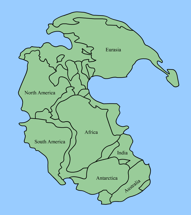
Alfred Wegener proposed that the continents were once assembled into a supercontinent called Pangaea.
Image:Pangaea continents.png
Wikipedia Commons Image.

He also proposed that Pangaea split into two parts:

    1) Northern Pangaea (which includes present day North America and Eurasia) became Laurasia.

    2) Southern Pangaea (including South America, Africa, India, Antarctica, and Australia) became Gondwanaland.

After Pangaea fragmented, Laurasia drifted northward and Gondwanaland drifted southward.
Wegener knew that coral reefs form near the equator, deserts form about 30° north and south of the equator, and glaciation occurs near the poles.  Based upon this information, he determined the North and South Pole positions over geologic time.  He called the apparent movement polar wandering.

There were two possible explanations:
    1) The continents remained motionless and the poles actually moved (literal polar wandering).

    2) The poles stood approximately still and the continents moved (continental drift).  Wegener preferred this explanation.
Opposition to Continental Drift

-Some scientists argued that some fossils (especially fossil plants) could have been spread from one continent to another by wind or ocean currents.

-Land dwelling reptiles could have spread from continent to continent by land bridges that rose up from the seafloor (this idea was pure speculation, as no appropriate mechanism was known).

-Wegener lacked a plausible mechanism by which continents could actually drift.

-Wegener's Polar wandering might reflect true wandering of poles rather than drifting of continents.
 New Evidence for Continental Drift
  
1) Paleomagnetism- The study of Earth’s magnetic field through time; geologists look at the way magnetic minerals in rocks preserve the magnetic field.

When a magnetic mineral crystallizes and cools below its Curie point, its magnetic alignment is locked in.

The direction of the mineral alignment gives the direction of magnetic North.  The dip of the mineral alignment gives the latitudinal distance from magnetic North.
  
For example, Permian age rocks in North America point to an apparent magnetic North pole in Asia whereas Permian age rocks in Europe point to an apparent magnetic North Pole in Japan.

Note: Today, when geologists use the term polar wandering they are referring to an “apparent” wandering of the poles.  We know that the poles themselves did not wander (although, as we shall see, the poles flipped or reversed many times throughout geologic history).

2) The continental slope- If the continental slope is taken into account, the plates fit together extremely well.

3) GPS technology- Global positioning satellites allow us to actually watch and measure the drift of the continents (1-16 cm/year).
Seafloor Spreading

Wegener thought that the seafloor remained stationary whereas the continents moved.

In contrast, in the 1960's Harry Hess proposed that the seafloor was also moving.

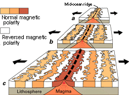
According to Hess, oceanic crust is produced at mid-ocean ridges and subducted at trenches.  The driving force for seafloor spreading is convection (hot mantle rises near the mid-ocean ridges and cold mantle sinks near trenches). 

The best evidence for sea floor spreading was provided by magnetometer surveys perpendicular to mid-ocean ridges.  A zebra pattern of magnetic reversals reflects episodic flips in Earth's North and South poles.

Image from the USGS.

The zebra pattern of magnetic anomalies is symmetrical about the ridge crest.

The concept of seafloor spreading explains the age of the sea floor.  Near mid-ocean ridges: sea floor is young and lacks sediment.  Away from ridges: seafloor gets older and acquires a thick blanket of pelagic sediment.
Image:Earth seafloor crust age 1996.gif
 The Big Picture: Plate Tectonics

By the late 1960’s, the hypotheses of continental drift and seafloor spreading had been combined into a single, unified theory of plate tectonics.

Recall that a plate is a thick, mobile slab of the Earth’s surface made of lithosphere (crust + upper mantle).  Plates glide on the ductile asthenosphere.

There are 3 types of tectonic plate boundaries:

1) Divergent Plate Boundaries

Divergent plate boundaries can occur in the middle of oceans or in the middle of a continent.

The result of a divergent plate boundary is to create a new ocean basin.

When a supercontinent like Pangaea breaks up, the divergent boundary is found in the middle of a continent, marked by a continental rift.

During the rifting event, the continental crust is stretched and thinned, producing a normal fault.  Topographically this results in a rift valley with a central graben.

The fault provides a pathway for basaltic magma, which rises up from the mantle to form basalt flows and cinder cones.

As divergence continues, sea water will eventually fill the split.

True oceanic crust is eventually produced at a mid ocean rift between the two diverging continents.

The trailing edge of the continent on each side of the rift becomes a passive margin.

2) Transform Boundaries

Transform boundaries involve strike-slip motion of plates (a conservative boundary).

Transform boundaries are characterized by shallow earthquakes.

The San Andreas fault is a transform boundary.  A previous plate was subducted, and after subduction was complete a subsequent plate arrived with a strike-slip orientation to the mainland.

Transform boundaries also occur along the fracture zones of mid-ocean ridges.

3) Convergent Plate Boundaries

At convergent plate boundaries, two plates move towards each other.

The character of the convergent boundary depends on the types of plates that are converging:

Ocean-ocean convergence-  One of the oceanic plates will subduct.  The subduction results in an island chain of volcanoes called an island arc (for example, the Phillipines).

Ocean-continent convergence- The dense oceanic crust is subducted below the continental crust.  A chain of volcanoes forms on the continental crust as a magmatic arc.

Regional metamorphism will occur due to the rising hot magmas and also due to the convergent forces.  On the landward side of the arc, a fold and thrust belt will form.

Continent-continent convergence-  In the case of continental-continental convergence, neither plate will subduct.  First, ocean floor in-between them the continents is subducted.  Eventually, when all the oceanic crust is subducted, the continents will collide.  The two continents will weld together along a suture zone.  Fold and thrust belts will form from the convergence and regional metamorphism will occur (Himalayan Mountains).

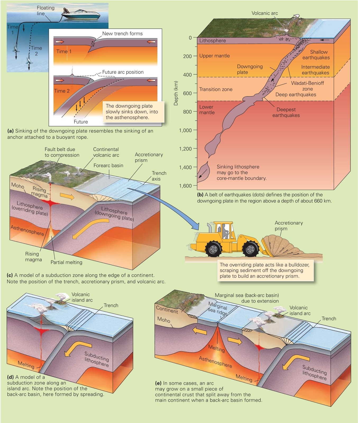
A closer look at subduction (for ocean-ocean or ocean-continent subduction).

A Benioff zone defined by shallow, intermediate, and deep earthquakes will define the top of the down-going plate.

At a depth of ~100 km, magmas will be generated in the asthenosphere overlying the down-going plate.  The magmas will rise upward, creating a chain of volcanoes on the overlying plate that parallel the subduction zone.
What Causes Plate Motions?

Rock deep within the Earth’s interior is heated and rises whereas shallow, colder denser rock sinks.  This sets up a convection current.

Huge convection cells may extend from the heat source at the core-mantle boundary all the way to the base of the lithosphere.

Several mechanisms assist in the movement of plates:

1) Ridge-push- Plates move apart at the midocean ridge due to down slopes. 

2) Slab-pull- Subducting slabs pull the surface part of the plate away from the ridge. 

3) Trench-suction- The subducting plate falls into the mantle.  As a result, the overlying trench and plate are pulled horizontally, seaward, toward the subducting plate.
Mantle Plumes and Hot Spots

A modification to the convection model suggests that the mantle transfers heat in the form of narrow columns of hot rock called mantle plumes.

The mantle plumes may rise from the core-mantle boundary and stay stationary.

The mantle plumes have a wide, mushroom-shaped head and a long, narrow tail.

Mantle plumes are proposed to produce “hot-spot” volcanic activity on the earth’s surface, sometimes far away from any plate margins.

Hawaii volcanism is “hot-spot” volcanism.  Hawaii is located in the middle of the Pacific plate, on oceanic crust.

Yellowstone volcanism is another example of “hot-spot” volcanism.  Yellowstone is located on the North American plate in the middle of continental crust.

Hot spot volcanism fed by a mantle plume is proposed to be the reason for the breakup of Pangaea.