Friday, February 26, 2016

Mineral Classification

Mineral Classification 

The 4,000 known minerals can be separated into a small number of groups, or mineral classes. You may think, “Why bother?” Classification schemes are useful because they help organize information and streamline discussion. Biologists, for example, classify animals into groups based on how they feed their young and on the architecture of their skeletons, and botanists classify plants according to the way they reproduce and by the shape of their leaves. In the case of minerals, a good means of classification eluded researchers until it became possible to determine the chemical makeup of minerals. A Swedish chemist, Baron Jöns Jacob Berzelius (1779–1848), analyzed minerals and noted chemical similarities among many of them. Berzelius, along with his students, established that most minerals can be classified by specifying the principal anion (negative ion) or anionic group (negative molecule) within the mineral. We now take a look at principal mineral classes, focusing especially on silicates, the class that constitutes most of the rock in the Earth.

Saturday, February 20, 2016

How Can You Tell One Mineral From Another?

How Can You Tell One Mineral From Another? 

Amateur and professional mineralogists get a kick out of recognizing minerals. They might hover around a display case in a museum and name specimens without bothering to look at the labels. How do they do it? The trick lies in learning to recognize the basic physical properties (visual and material characteristics) that distinguish one mineral from another. Some physical properties, such as shape and colour, can be seen from a distance. Others, such as hardness and magnetization, can be determined only by handling the specimen or by performing an identification test on it. Identification tests include scratching the mineral by another object, placing it near a magnet, weighing it, tasting it, or placing a drop of acid on it. Let’s examine some of the physical properties most commonly used in basic mineral identification.

Monday, February 15, 2016

What Drives Plate Motion, and How Fast Do Plates Move?

What Drives Plate Motion, and How Fast Do Plates Move? 

Forces Acting on Plates 

We've now discussed the many facets of plate tectonics theory but to complete the story, we need to address a major question: “What drives plate motion?” When geoscientists first proposed plate tectonics, they thought the process occurred simply because convective flow in the asthenosphere actively dragged plates along, as if the plates were simply rafts on a flowing river. Thus, early images depicting plate motion showed simple convection cells elliptical  flow paths in the asthenosphere. At first glance, this hypothesis looked pretty good. But, on closer examination it became clear that a model of simple convection cells carrying plates on their backs can’t explain the complex geometry of plate boundaries and the great variety of plate motions that we observe on the Earth. Researchers now prefer a model in which convection, ridge push, and slab pull all contribute to driving plates. Let’s look at each of these phenomena in turn.

How Do Plate Boundaries Form and Die?

How Do Plate Boundaries Form and Die? 

The configuration of plates and plate boundaries visible on our planet today has not existed for all of geologic history, and will not exist indefinitely into the future. Because of plate motion, oceanic plates form and are later consumed, while continents merge and later split apart. How does a new  divergent boundary come into existence, and how does an existing convergent boundary eventually cease to exist? Most new divergent boundaries form when a continent splits and separates into two continents. We call this process rifting. A convergent boundary ceases to exist when a piece of buoyant lithosphere, such as a continent or an island arc, moves into the subduction zone and, in effect, jams up the system. We call this process collision.

Wednesday, February 10, 2016

Transform Plate Boundaries

Transform Plate Boundaries

The concept of transform faulting.
When researchers began to explore the bathymetry of midocean ridges in detail, they discovered that mid-ocean ridges are not long, uninterrupted lines, but rather consist of short segments that appear to be offset laterally from each other (figure above a) by narrow belts of broken and irregular sea floor. These belts, or fracture zones, lie roughly at right angles to the ridge segments, intersect the ends of the segments, and extend beyond the ends of the segments. Originally, researchers incorrectly assumed that the entire length of each fracture zone was a fault, and that slip on a fracture zone had displaced segments of the mid-ocean ridge sideways, relative to each other. In other words, they imagined that a mid-ocean ridge initiated as a continuous, fence-like line that only later was broken up by faulting. But when information about the distribution of earthquakes along mid-ocean ridges became available, it was clear that this model could not be correct. Earthquakes, and therefore active fault slip, occur only on the segment of a fracture zone that lies between two ridge segments. The portions of fracture zones that extend beyond the edges of ridge segments, out into the abyssal plain, are not seismically active.

Convergent Plate Boundaries and Subduction

Convergent Plate Boundaries and Subduction 

At convergent plate boundaries, two plates, at least one of which is oceanic, move toward one another. But rather than butting each other like angry rams, one oceanic plate bends and sinks down into the asthenosphere beneath the other plate. Geologists refer to the sinking process as subduction, so convergent boundaries are also known as subduction zones. Because subduction at a convergent boundary consumes old ocean lithosphere and thus ‘‘consumes’’ oceanic basins, geologists also refer to convergent boundaries as consuming boundaries, and because they are delineated by deep-ocean trenches, they are sometimes simply called trenches. The amount of oceanic plate consumption worldwide, averaged over time, equals the amount of sea-floor spreading worldwide, so the surface area of the Earth remains constant through time. 

During the process of subduction, oceanic lithosphere sinks back into the deeper mantle.

What Do We Mean by Plate Tectonics?

What Do We Mean by Plate Tectonics?

The paleomagnetic proof of continental drift (plate tectonics) and the discovery of sea-floor spreading set off a scientific revolution in geology in the 1960s and 1970s. Geologists realised that many of their existing interpretations of global geology, based on the premise that the positions of continents and oceans remain fixed in position through time, were simply wrong! Researchers dropped what they were doing and turned their attention to studying the broader implications of continental drift and sea-floor spreading. It became clear that these phenomena required that the outer shell of the Earth was divided into rigid plates that moved relative to each other. New studies clarified the meaning of a plate, defined the types of plate boundaries, constrained plate motions, related plate motions to earthquakes and volcanoes, showed how plate interactions can explain mountain belts and seamount chains, and outlined the history of past plate motions. From these, the modern theory of plate tectonics evolved. Below, we first describe lithosphere plates and their boundaries, and then outline the basic principles of plate tectonics theory.

The Concept of a  Lithosphere Plate 

 Nature of the lithosphere and its behaviour.
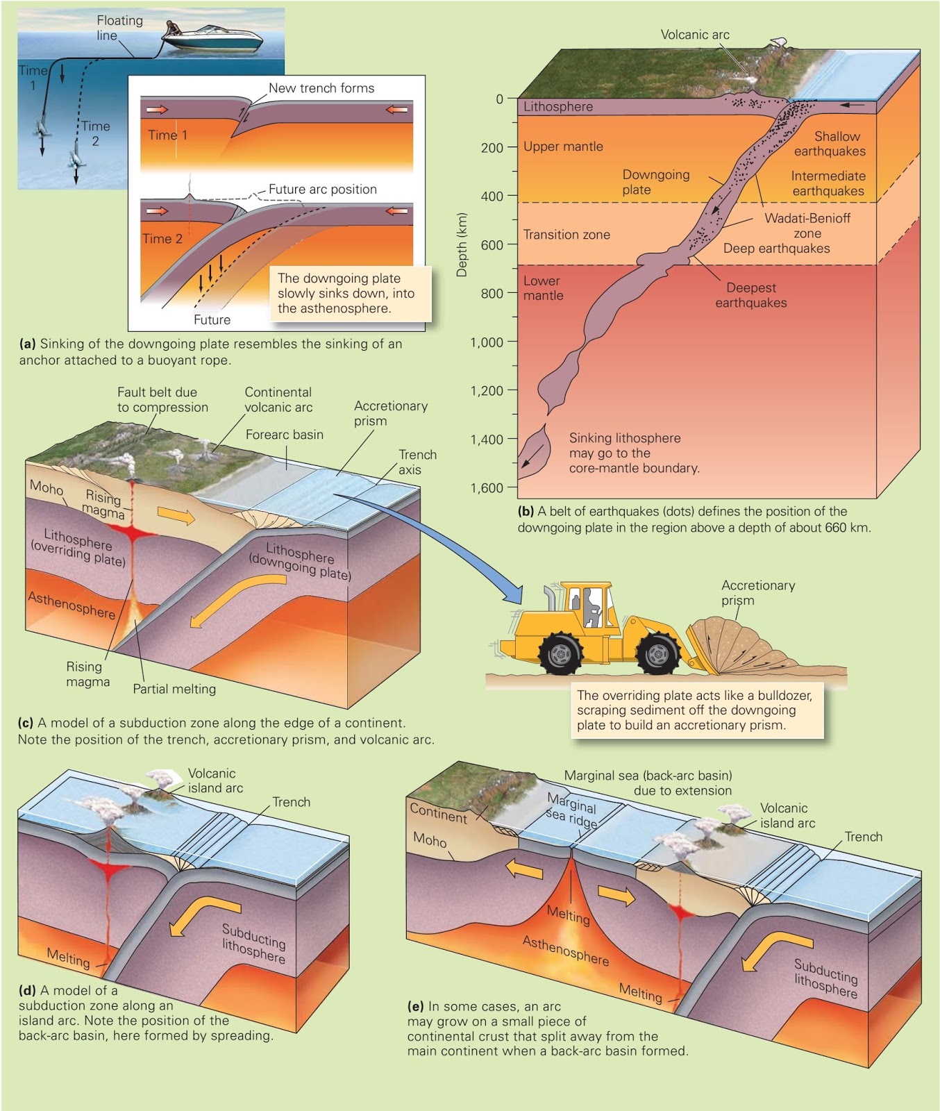
We learned earlier that geoscientists divide the outer part of the Earth into two layers. The lithosphere consists of the crust plus the top (cooler) part of the upper mantle. It behaves relatively rigidly, meaning that when a force pushes or pulls on  it, it does not flow but rather bends or breaks (figure above a). The lithosphere floats on a relatively soft, or “plastic,” layer called the asthenosphere, composed of warmer ( 1280°C) mantle that can flow slowly when acted on by a force. As a result, the asthenosphere convects, like water in a pot, though much more slowly.
Continental lithosphere and oceanic lithosphere differ markedly in their thicknesses. On average, continental lithosphere has a thickness of 150 km, whereas old oceanic lithosphere has a thickness of about 100 km (figure above b). (For reasons discussed later in this chapter, new oceanic lithosphere at a mid-ocean ridge is much thinner.) Recall that the crustal part of continental lithosphere ranges from 25 to 70 km thick and consists largely of low-density felsic and intermediate rock. In contrast, the crustal part of oceanic lithosphere is only 7 to 10 km thick and consists largely of relatively high-density mafic rock (basalt and gabbro). The mantle part of both continental and oceanic lithosphere consists of very high-density ultramafic rock (peridotite). Because of these  differences, the continental lithosphere “floats” at a higher level than does the oceanic lithosphere. 

The location of plate boundaries and the distribution of earthquakes.
The lithosphere forms the Earth’s relatively rigid shell. But unlike the shell of a hen’s egg, the lithospheric shell contains a number of major breaks, which separate it into distinct pieces. As noted earlier, we call the pieces lithosphere plates, or simply plates. The breaks between plates are known as plate boundaries (figure above a). Geoscientists distinguish twelve major plates and several microplates. 

The Basic Principles of Plate Tectonics 

With the background provided above, we can restate plate tectonics theory concisely as follows. The Earth’s lithosphere is divided into plates that move relative to each other. As a plate moves, its internal area remains mostly, but not perfectly, rigid and intact. But rock along plate boundaries undergoes intense deformation (cracking, sliding, bending, stretching, and squashing) as the plate grinds or scrapes against its neighbours or pulls away from its neighbours. As plates move, so do the continents that form part of the plates. Because of plate tectonics, the map of Earth’s surface constantly changes.

Identifying Plate Boundaries 

How do we recognize the location of a plate boundary? The answer becomes clear from looking at a map showing the locations of earthquakes (figure above b). Recall from Chapter 1 that earthquakes are vibrations caused by shock waves that are generated where rock breaks and suddenly slips along a fault. The epicentre marks the point on the Earth’s surface directly above the earthquake. Earthquake epicentres do not speckle the globe randomly, like buckshot on a target. Rather, the majority occur in relatively narrow, distinct belts. These earthquake belts define the position of plate boundaries because the fracturing and slipping that occurs along plate boundaries generates earthquakes. Plate interiors, regions away from the plate boundaries, remain relatively earthquake-free because they do not accommodate as much movement. While earthquakes serve as the most definitive indicator of a plate boundary, other prominent geologic features also develop along plate boundaries.
Note that some plates consist entirely of oceanic lithosphere, whereas some plates consist of both oceanic and continental lithosphere. Also, note that not all plates are the same size (figure above c). Some plate boundaries follow continental margins, the boundary between a continent and an ocean, but others do not. For this reason, we distinguish between active margins, which are plate boundaries, and passive margins, which are not plate boundaries. Earthquakes are common at active margins, but not at passive margins. Along passive margins, continental crust is thinner than in  continental interiors. Thick (10 to 15 km) accumulations of sediment cover this thinned crust. The surface of this sediment layer is a broad, shallow (less than 500 m deep) region called the continental shelf, home to the major fisheries of the world. 

The three types of plate boundaries differ based on the nature of relative movement.
Geologists define three types of plate boundaries, based simply on the relative motions of the plates on either side of the boundary (figure above a–c). A boundary at which two plates move apart from each other is a divergent boundary. A boundary at which two plates move toward each other so that one plate sinks beneath the other is a convergent boundary. And a boundary at which two plates slide sideways past each other is a transform boundary.
Credits: Stephen Marshak (Essentials of Geology)

Monday, February 1, 2016

Evidence for Sea-Floor Spreading

Evidence for Sea-Floor Spreading 

For a hypothesis to become a theory, researchers must demonstrate that the idea really works. During the 1960s, geologists found that the sea-floor spreading hypothesis successfully explains several previously baffling observations. Here we discuss two: (1) the existence of orderly variations in the strength of the measured magnetic field over the sea floor, producing a pattern of stripes called marine magnetic anomalies; and (2) the variation in sediment thickness on the ocean crust, as measured by drilling.

Marine Magnetic Anomalies

Recognizing anomalies 

Geologists can measure the strength of Earth’s magnetic field with an instrument called a magnetometer. At any given location on the surface of the Earth, the magnetic field that you measure includes two parts: one produced by the main dipole of the Earth generated by circulation of molten iron in the outer core, and another produced by the magnetism of near-surface rock. A magnetic anomaly is the difference between the expected strength of the Earth’s main dipole field at a certain location and the actual measured strength of the magnetic field at that location. Places where the field strength is stronger than expected are positive anomalies, and places where the field strength is weaker than expected are negative anomalies.

The Discovery of Sea-Floor Spreading

The Discovery of Sea-Floor Spreading

New Images of Sea-Floor Bathymetry 

Bathymetry of mid-ocean ridges and abyssal plains.
Military needs during World War II gave a boost to sea-floor exploration, for as submarine fleets grew, navies required detailed information about bathymetry, or depth variations. The invention of echo sounding (sonar) permitted such information to be gathered quickly. Echo sounding works on the same principle that a bat uses to navigate and find insects. A sound pulse emitted from a ship travels down through the water, bounces off the sea floor, and returns up as an echo through the water to a receiver on the ship. Since sound waves travel at a known velocity, the time between the sound emission and the echo detection indicates the distance between the ship and the sea floor. (Recall that  velocity distance/time, so distance velocity s time.) As the ship travels, observers can obtain a continuous record of the depth of the sea floor. The resulting cross section showing depth plotted against location is called a bathymetric profile (figure above a, b). By cruising back and forth across the ocean many times, investigators obtained a series of bathymetric profiles and from these constructed maps of the sea floor. (Geologists can now produce such maps much more rapidly using satellite data.) Bathymetric maps reveal several important features.

Paleomagnetism and the Proof of Continental Drift

Paleomagnetism and the Proof of Continental Drift

More than 1,500 years ago, Chinese sailors discovered that a piece of lodestone, when suspended from a thread, points in a northerly direction and can help guide a voyage. Lodestone exhibits this behaviour because it consists of magnetite, an iron rich mineral that, like a compass needle, aligns with Earth’s magnetic field lines. While not as magnetic as lodestone, several other rock types contain tiny crystals of magnetite, or other magnetic minerals, and thus behave overall like weak magnets. In this section, we explain how the study of such magnetic behaviour led to the realization that rocks preserve paleomagnetism, a record of Earth’s magnetic field in the past. An understanding of paleomagnetism provided proof of continental drift and, contributed to the development of plate tectonics theory. As a foundation for introducing paleomagnetism, we first provide additional detail about the basic nature of the Earth’s magnetic field.

Earth’s Magnetic Field 

Features of Earth’s magnetic field.
Circulation of liquid iron alloy in the outer core of the Earth generates a magnetic field. (A similar phenomenon happens in an electrical dynamo at a power plant.) Earth’s magnetic field resembles the field produced by a bar magnet, in that it has two ends of opposite polarity. Thus, we can represent Earth’s field by a magnetic dipole, an imaginary arrow (figure above a). Earth’s dipole intersects the surface of the planet at two points, known as the magnetic poles. By convention, the north magnetic pole is at the end of the Earth nearest the north geographic pole (the point where the northern end of the spin axis intersects the surface). The north-seeking (red) end of a compass needle points to the north magnetic pole.